


2023-03-02_11h00m56_SityTrail - 3565569 - Campel_TA_Rando A+

ballay
User
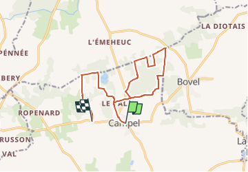

Length
13.2 km

Max alt
130 m

Uphill gradient
194 m
Km-Effort
15.8 km

Min alt
79 m

Downhill gradient
184 m
Boucle
No
Creation date :
2023-03-02 10:00:56.248
Updated on :
2023-03-02 10:00:56.681

FREE GPS app for hiking
 SityTrail
IGN / Geographical institutes
SityTrail Plus
The world is yours!
About
Trail of 13.2 km to be discovered at Brittany, Ille-et-Vilaine, Val d'Anast. This trail is proposed by ballay.
Positioning
Country:
France
Region :
Brittany
Department/Province :
Ille-et-Vilaine
Municipality :
Val d'Anast
Location:
Unknown
Start:(Dec)
Start:(UTM)
574050 ; 5309697 (30T) N.
Comments